There’s a lot of good stuff out there, and a lot of strange stuff as well. On this page we hope to provide some of the better stuff.
Listening to the Shortwave Bands on a web browser ( or “look mum, no radio!!)
One of the best ways to learn about Amateur Radio operating procedures is to listen, listen and listen some more. If you don’t have equipment that can tune the Amateur Bands you can use any one of a multitude of online Software Defined Radios ( SDR) that are available. You can also use these for general listening across the bands. Click here to read all about this magnificent resource.
MORSE Code
A site developed by W6RCF. https://morsefree.com/
What I’m seeing is similar to how I learned CW back in the mid 70s, using cassette tapes on a portable machine. It starts with just dits then the common dahs and goes on from there. Each exercise is short and easy to follow. See what you think. Cheers… Robert VK3ARM
Searching for old callsigns.. Though this is NorthAmericia centric it has some resources. The callbooks that include the word “foreign” include VK callsigns. Direct to the callbooks.
Archive . Org has a good collection of Old Callbooks available. Click here for the search
From the FAQ page ” You hike to the top of a mountain or pull off at a scenic overlook. You see mountains in the distance. Which mountains are they? HeyWhatsThat will tell you, providing a 360° panoramic sketch labeled with the names of the peaks you’re looking at. From almost anywhere in the world.“
and it also ..”..computes the horizon and mountain names and other related visualizations, including the surface of the Earth visible from where you’re standing (the visibility cloak or viewshed) and the line of sight profile between you and the distant peaks.”
This is how I played with it :
from the main page, clicked on “NewPanorama”
Enter an ADDRESS ( or use the map to set a centre of interest),
Enter a title, and click the button “Submit request”
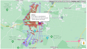
Wait for about a minute for the screen to refresh, and it presents a map centred on the address that you entered:

The RED stuff is the “visibility cloak”, supposedly what I should be able to see from my antenna at 4m height.
It also produces a profile of what I should see from the address:

Some others:
https://www.scadacore.com/tools/rf-path/rf-line-of-sight/
https://www.solwise.co.uk/wireless-elevationtool.html (Video Demonstration)
Splat Maps ( What an Interesting name). A good description is here
Radio Frequency National Site Archive (RFNSA)
2025-08-20